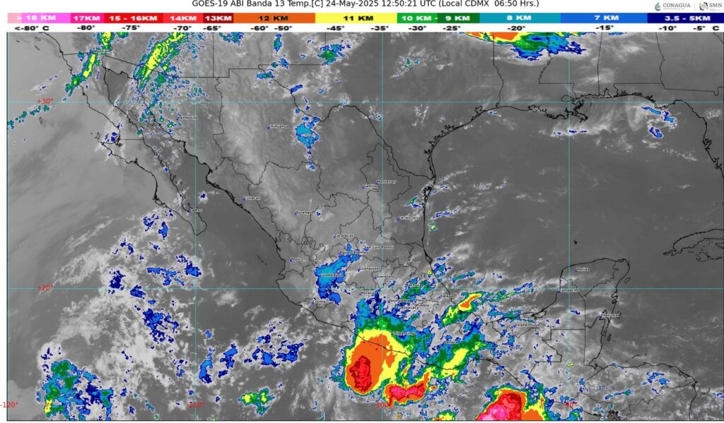
🔸 Continuará el calor extremo en zonas del norte, occidente, sur y sureste, mientras una onda tropical se aproxima a la Península de Yucatán.
#NACIONAL🇲🇽 II Buenos días ☀️ ll El Servicio Meteorológico Nacional pronostica para hoy, Canales de baja presión sobre la mesa del Norte y sureste de la República Mexicana, en interacción con inestabilidad atmosférica y el ingreso de humedad del océano Pacífico, golfo de México y mar Caribe, producirán chubascos y lluvias fuertes acompañadas con descargas eléctricas y posible caída de granizo en el norte, noreste, oriente, centro, occidente, sur y sureste del país, incluidos el Valle de México y la península de Yucatán; pronosticándose lluvias muy fuertes a puntuales intensas en Guerrero, Veracruz, Oaxaca y Chiapas.
Por otra parte, una línea seca sobre el norte de México, generará rachas de viento de 50 a 70 km/h con posible formación de torbellinos en Chihuahua y Coahuila. Prevalecerá el ambiente caluroso a muy caluroso sobre el territorio nacional, con onda de calor en Sinaloa, Nayarit (norte), Jalisco (suroeste, centro y sur), Colima, Michoacán (oeste, suroeste y este), Guerrero (noroeste, oeste, costa y sureste), Oaxaca (sur y sureste), Chiapas (oeste y centro), Coahuila (centro y suroeste), Durango (noreste y oeste) y Campeche (norte), finalizando este día en los estados de Zacatecas, Morelos y Puebla.
Por la tarde, una onda tropical se aproximará al sur de la península de Yucatán.
Península de Yucatán: Cielo medio nublado a nublado durante el día con lluvias aisladas y posibles descargas eléctricas en la región. Por la mañana, ambiente templado a cálido, así como caluroso a muy caluroso durante la tarde, prevaleciendo la onda de calor en Campeche (norte). Viento de componente este de 10 a 20 km/h con rachas de 40 a 60 km/h en la región.


Thank you for another excellent article. Where else could anyone get that type of info in such an ideal way of writing? I have a presentation next week, and I’m on the look for such info.
I’ve been absent for some time, but now I remember why I used to love this site. Thanks, I’ll try and check back more frequently. How frequently you update your website?
My wife and i have been really joyous when Jordan could complete his analysis by way of the ideas he acquired when using the web page. It is now and again perplexing to just be giving out hints that many a number of people have been trying to sell. And now we remember we now have you to give thanks to for this. The specific illustrations you have made, the straightforward site menu, the friendships you aid to engender – it is all overwhelming, and it’s aiding our son and our family consider that the topic is exciting, which is quite pressing. Thanks for the whole lot!
Hello There. I found your blog using msn. This is an extremely well written article. I’ll be sure to bookmark it and come back to read more of your useful info. Thanks for the post. I’ll definitely return.
It’s a pity you don’t have a donate button! I’d most certainly donate to this fantastic blog! I guess for now i’ll settle for book-marking and adding your RSS feed to my Google account. I look forward to new updates and will share this website with my Facebook group. Talk soon!
It’s really a nice and useful piece of information. I am glad that you shared this useful information with us. Please keep us informed like this. Thank you for sharing.
Thanks for any other wonderful article. Where else may anybody get that type of information in such an ideal way of writing? I have a presentation next week, and I am at the search for such information.
This is a very good tips especially to those new to blogosphere, brief and accurate information… Thanks for sharing this one. A must read article.
Thanks for another informative website. The place else may just I am getting that kind of info written in such a perfect way? I have a challenge that I’m just now running on, and I’ve been on the look out for such information.
Hiya very cool website!! Guy .. Excellent .. Superb .. I will bookmark your web site and take the feeds also?KI’m happy to search out a lot of helpful information here within the submit, we want work out more strategies on this regard, thanks for sharing. . . . . .
Sweet website , super layout, rattling clean and utilize friendly.
I simply had to say thanks all over again. I’m not certain the things that I would have made to happen in the absence of the type of tips discussed by you on such area. It had become an absolute daunting issue for me personally, nevertheless viewing the very specialised avenue you handled it forced me to leap with joy. I will be thankful for the service and then hope that you realize what a great job that you’re doing teaching men and women thru your webpage. I know that you haven’t met all of us.
Lovely just what I was looking for.Thanks to the author for taking his time on this one.