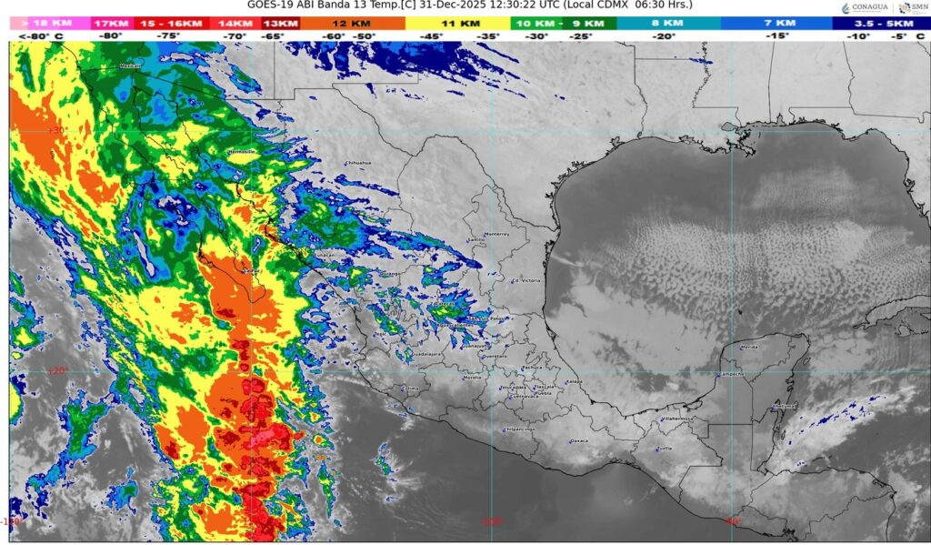
🔸Continuará registrándose evento de “Norte” muy fuerte a intenso en el istmo y golfo de Tehuantepec, Veracruz y eb costas de Tabasco, Campeche, Yucatán y Quintana Roo.
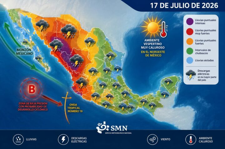
#NACIONAL🇲🇽 II Buenos días ☀️ ll Para hoy, el frente frío número 25 dejará de afectar a México, sin embargo, la masa de aire ártico asociada a él, cubrirá el noreste, oriente y sureste de México, incluida la península de Yucatán, manteniendo lluvias puntuales fuertes en Veracruz (Los Tuxtlas y Olmeca), Oaxaca, Chiapas y Tabasco; chubascos en Puebla, Campeche y Quintana Roo; así como lluvias aisladas en Yucatán.
Continuará registrándose evento de “Norte” muy fuerte a intenso de 40 a 60 kilómetros por hora (km/h) con rachas de 70 a 90 km/h en el istmo y golfo de Tehuantepec, vientos de 30 a 40 km/h con rachas de 50 a 70 km/h, disminuyendo durante la tarde, en la costa de Veracruz (centro y sur), y vientos de 20 a 30 km/h con rachas de 40 a 60 km/h en costas de Tabasco, Campeche, Yucatán y Quintana Roo, con oleaje elevado en costas de dichos estados; además persistirá el ambiente muy frío a frío con heladas en entidades de la Mesa del Norte y la Mesa Central, incluyendo al Valle de México, y con bancos de niebla en el oriente y sureste del país.
Se prevé que al finalizar el día la masa de aire ártico comenzará a modificar sus características térmicas.
Por otra parte, una vaguada en niveles medios y altos de la atmósfera frente a la costa occidental de la península de Baja California, en interacción con un río atmosférico y con la corriente en chorro subtropical, originarán rachas fuertes de viento, lluvias puntuales muy fuertes en la Península de Baja California e intervalos de chubascos en Chihuahua y Sinaloa, así como probabilidad de caída de nieve o aguanieve durante la noche en la sierra de San Pedro Mártir, B.C.
Finalmente, el ingreso de humedad del océano Pacífico propiciará lluvias y chubascos en el occidente y sur del territorio nacional.


That is really interesting, You are an overly professional blogger. I’ve joined your rss feed and stay up for searching for more of your magnificent post. Additionally, I’ve shared your website in my social networks!
Really clean internet site, thanks for this post.
I believe this site has some real wonderful info for everyone :D.
I don’t even know how I stopped up right here, however I believed this put up used to be good. I don’t know who you are however certainly you’re going to a well-known blogger if you happen to aren’t already 😉 Cheers!
I enjoy forgathering useful info, this post has got me even more info! .
My brother suggested I might like this website. He was totally right. This post truly made my day. You can not imagine just how much time I had spent for this information! Thanks!
I am also writing to let you know what a magnificent encounter our child enjoyed browsing your webblog. She discovered so many issues, which include what it is like to possess a very effective giving mood to let many people completely master selected hard to do topics. You really exceeded our expectations. Many thanks for providing the valuable, trustworthy, informative and also cool tips on the topic to Ethel.
Terrific paintings! That is the type of information that should be shared across the net. Shame on Google for no longer positioning this post higher! Come on over and seek advice from my site . Thank you =)
I am not sure where you’re getting your info, but good topic. I needs to spend some time learning much more or understanding more. Thanks for fantastic information I was looking for this information for my mission.
Hello! This is my first visit to your blog! We are a team of volunteers and starting a new project in a community in the same niche. Your blog provided us useful information to work on. You have done a wonderful job!
Wow, awesome blog layout! How long have you been blogging for? you made blogging look easy. The overall look of your web site is excellent, as well as the content!
Do you mind if I quote a few of your posts as long as I provide credit and sources back to your weblog? My website is in the exact same area of interest as yours and my users would definitely benefit from some of the information you provide here. Please let me know if this okay with you. Many thanks!
I discovered your blog site on google and check a few of your early posts. Continue to keep up the very good operate. I just additional up your RSS feed to my MSN News Reader. Seeking forward to reading more from you later on!…
I like what you guys are up too. Such smart work and reporting! Keep up the superb works guys I have incorporated you guys to my blogroll. I think it will improve the value of my site 🙂